E-FARM MONITORING
We would like to spot your attention to a very specific farm management system designed purely for the needs of agricultural companies and government institutions involved in land cultivation – this system is Cropio Farm Management. It is specific due to the fact that it is based on satellite technology that generates numerous opportunities for the improving performance and decision-making in agricultural companies and government agriculture institutions.
B Crops is a certified agent in the region to provide Cropio Satellite Monitoring System.
In order to use efficiently this system, B Crops offer service of mapping your fields and enter initials data in the system. B Crops train users how to use this system to allow them benefiting on the output of the latest Satellite farm monitoring system.
Government institutions, farm Managers and owners:
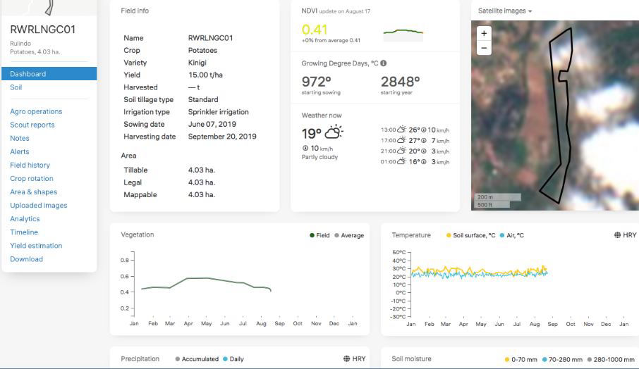
The system allows the managers and the owners to see the structure of the crops in the field and also view a map of the crops in different colors. The different colors in the map are a distinction of the various vegetation levels available in the farm and different soil structures. It also gives you latest updated HD satellite maps.
This system allow the managers to create and assign specific task on a particular field and monitor its implementation through the work reporting features in the system.
It allows planning a cropping pattern of your field by planning crop rotation on your farm.
The system allows the managers and also the owners to monitor their growth and also their yield of the farm over a period of years so as to see if there are any areas that can be improved so as to improve the yield. This information also helps the owners and the managers to make decisions relating to sales and cash management so as to enable the farm to spend to levels that it can finance itself.
Agronomist and field officers:The system allows the agronomist and field officers to monitor the changes of the crops by providing information on a daily/weekly basis. The agronomist therefore monitors the crops by deducing the discrepancies that is there in the crops from what was there in the previous week. The agronomists are therefore able to monitor all the sections of the farm and in the long run he or she will be able to identify the areas that are producing low yields. After the identification of the low yield areas, the agronomist is then able to take necessary action to facilitate the improvement of those areas. Some of these areas include the application of additional fertilizer to that region so as to ensure that its fertility is the same as those of the other regions of the farm.
It also guides you in your soil sampling exercise and allow saving soil analysis result in the systems.